Living in Beauxart Gardens in the 1930’s


I can vaguely remember my father telling stories of my family’s life in Beauxart Gardens where they lived for a short time before moving to 18th Street in Port Arthur. I particularly recall being told of an event in which my grandfather was bitten by a tarantula in the garden. But I really cannot confirm that tarantulas even existed in Southeast Texas in the 30s (most likely just big wolf spiders—but wolf spiders don’t make as good a story as a tarantula when you’re talking to a 10-year-old).

* * *

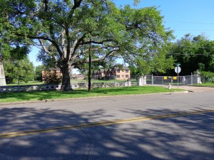
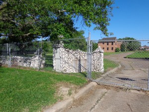
The other day I heard it mentioned that the Beauxart Gardens marker had been knocked down. My first thought was to wonder why Beauxart Gardens had a marker to begin with. And so goes the journey. I was immediately given the answer to “why,” and this led to another interesting story that I had no idea existed.

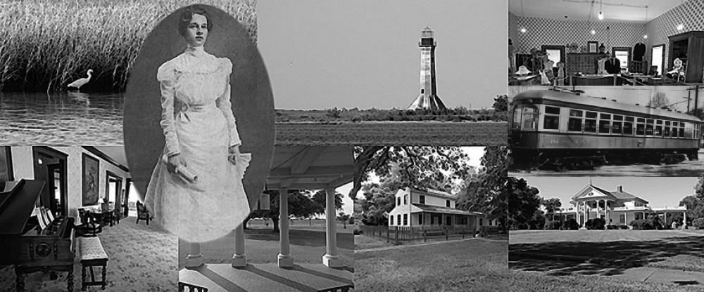
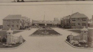
Beauxart Gardens was one of five farm/homestead colonies in Texas, which were developed in 1934 as part as of the New Deal legislation. Under President Franklin Roosevelt, this piece of legislation, among other things, provided housing to displaced Americans who couldn’t meet their mortgage payments and had been foreclosed upon. Generally, such residents in Southeast Texas worked part-time at area refineries and also kept vegetable gardens and livestock. The Beauxart area included not only 50 homestead sites, but two park sites, the largest of which (nine acres) contained a community center and playground. (This is the park located between Central Drive and South Garden Drive.)

Having had family that lived there for a time, I thought it best to go to the source in order to find out more about the place. So I called my uncle for a firsthand view of life in Beauxart Gardens, and the conversation was priceless.

My family had lived there for about three years. It was a great place to live and certainly to raise kids, but it was, at the time, away from civilization. There was no town to speak of: no stores or no churches, just pasture lands and gardens. My grandmother, in particular, did not like living that far away from her church (St. James on 16th Street in Port Arthur), but you did what you had to do back then, I guess.

The children were bused to Nederland schools, which posed a problem if a child wanted to participate in after-school programs. This was the 30s, and unlike today, ownership of cars was not widespread.

My grandfather worked at the Texas Company. The hours after work and at off times were spent tending to the garden. The family also had cows. Those necessities and other groceries were purchased at the Texas Company store, which my grandfather would visit every Saturday. Learning about his Saturday trips resonates with me because my father would do the same, although I’m sure Howard’s on 9th Avenue had a bit more of a selection than the Texas Company store.

After speaking with my uncle, I felt that the memories of growing up in Beauxart Gardens were kindly, although I do know that times were hard, especially given that people were in the grasp of the Depression. But our family has never shied away from hard work, and my grandparents raised six great kids in the process.

If you or someone you know has a story about growing up in Beauxart Gardens, or Southeast Texas in general, I would love to hear it. You can contact me at rediscoveringsetx@gmail.com. Let’s not allow our history to disappear. It’s not about the big battles or the status. Our history comprises the lives of the ordinary people who made SETX interesting.

Food for Thought in Port Arthur Texas (70’s- 80’s)


Growing up in Port Arthur in the 1970s did have its finer points to some degree. As a kid I had no idea what Bernis Sadler (then the mayor) was up to nor did I care. My main concern was whether or not Monceaux Drive In had those delectable and greasy onion rings with my cheeseburger deluxe served in a cardboard pie box. Truth be told, there is nothing that comes close to those onion rings! (Baby Boomers will remember Monceaux’s for the root-beer among other things.)

Over the course of two decades, I have discovered many eateries in my hometown, and there were many. One that comes to mind is a little takeout place called Hartman’s, which was located on Bluebonnet Avenue. If you loved home-style cooking, then this was a gem. I can remember walking in and feeling as if I was in someone’s house, except for the screen door attached to the kitchen from which an elderly man emerged with your plate lunch after you had ordered it from a very nice elderly lady.

These two people were delightful. As far as I could tell, these were the Hartman’s, and one could believe this except for their heavy Cajun accents. One thing that sticks out in my mind is that, when I would call ahead, the lady would ask what I wanted. My answer, of course, was the Étouffée, but there were many things besides the main course. “So what are the sides?”

“Well, we got lima beans, string beans, pinto beans, red beans, white beans, and (it always ended with) black-eyed peas.”

Whatever the sides, this was something to treasure. Speaking of treasure, I also remember a place next to Roy’s Food Center on Lewis Drive called the Brisket Room. The chip beef sandwiches were the best barbeque—or at least they were until I found Billy Joe’s in Port Neches.

Port Arthur seemed to always promote itself as the friendliest city by the sea. Well, Port Arthur is not by the sea, it’s by a lake, but I will give credit to the seafood. There were three restaurants that I enjoyed. The first and foremost was Leo and Willie’s. There was no place better in the 80s—except on Thursdays. On Thursdays I would order a seafood platter from the Texas Fish Net Restaurant. There was no one who had better catfish than the Fish Net!

And let us not forget about the Farm Royale on Memorial. Back in the day, most knew this place to be an upper-class eatery, and they weren’t mistaken. Other eateries offering decent seafood (technically I do not know if they are in Port Arthur, but they are worth mentioning) are Domingue’s on the Neches (under the Rainbow Bridge) and of course, Esther’s. Yes, I do know the latter is in Groves, Texas, but it was just a great place to eat back when.

Finally, sometimes we craved Mexican food, and there was no better place at the time to treat ourselves than under the train bridge at Taco Rey, or my favorite, Guadalajara on 9th Avenue. Both had pretty good Tex-Mex food. Nowadays Taco Rey can be found on Nederland (where it’s safe), and Guadalajara still has a restaurant in Orange Texas.

Please forgive this minor indulgence because this blog really has no historic value other than me remembering those greasy onion rings, chip beef sandwiches, plate lunches, catfish, and tacos from places and times long since passed.


Eddingston Court Port Arthur Texas

Eddingston Court 1929

There is one place in Port Arthur that has always fascinated me even though I’ve never had the pleasure of visiting it. Over the years, the grounds of Eddingston Court have made me think of English-inspired flats and gardens. So how did this property come to be, and what is its history?

In 1929 Port Arthur was short of rental properties due in part to the expanding oil industry. Tugboat captain and businessman Ambrose Eddingston saw an opportunity and commissioned the construction of four two-story Tudor brick apartment buildings along with a pond, which lay in the middle of the drive between the buildings. A one-story brick ranch-style home was also built at the end of the drive.DSC00039

Given the time it was built, circa 1929, it must have been quite a sight to see the finished edifice. I have personally always been a fan of English architecture and gardens, so to have been among the Port Arthur residents of the period would no doubt have just added to my ardor.

Given the eccentric flare of the property’s pond and structures, you would think that these would have been sufficient, but Ambrose Eddingston had another visual treat for passersby. The captain had 6,000 Conch shells imported from the Caymen Islands, and these went into the construction of a wall at the front of the property. Ambrose Eddingston commissioned Dionicio Rodriguez, a Mexican-born sculpture who was living in San Antonio at the time, to construct the fence and the pond. (As an aside, Rodriguez was not only known for his wonderful works, but he also perfected a process in which he carved chemically treated reinforced concrete so that it looked like wood.)

During the subsequent 76 years, this property underwent a few minor changes but still maintained its English-style charm, providing tenants with a place to call home. Some residents even stayed for multiple decades. Sadly, just as with many other properties in this area, Hurricane Rita unleashed her fury upon it, and it was damaged. In 2008, Hurricane Ike also damaged the structures, and it has lain vacant ever since.

DSC00041

Nowadays, you will notice as you go past the property that this glamorous artistic treasure is barricaded by a chain link fence, and a “For Sale” sign is in plain view. I can only imagine the state of the structures, which have been left as is, waiting until a new owner comes in and restores this historic gem to its former glory. Hopefully this is one Port Arthur property that will escape the wrecking ball, unlike so many other buildings over the years that have not.

Rediscovering Anahuac / Wallisville


DSC03932


If you’re like me, Anahuac is an exit sign off the I-10, which you pass as you go to and from Houston. Yes, you may notice a few old buildings lined up next to the post office, and if you’re really observant, you may see the old church that sits in the background amongst the many old oaks along the streets. A thought might enter your mind to visit this place one day and find out what these old buildings are and why they were built in the first place. But, if you’re like me, your life will get in the way, and you will forget—until your next trip to Houston.

Well, let’s flashback to last year. I acquired a job in Anahuac itself and my travels took me much farther than Exit 813 by the McDonalds. I found out that Anahuac is actually about seven miles south of the Interstate. So every other week, I travelled to this city, oblivious to its rich historic past.

One day, I made a wrong turn and ended up near the Chambers County courthouse. An odd old house caught my eye. It was two-story dwelling with nice porches and a very interesting window. I immediately stopped and felt compelled to investigate.

DSC03926

The house had belonged to a certain Thomas Jefferson Chambers, a lawyer, land speculator, and namesake for Chambers County.

Fast-forward to a few weeks ago when I took a trip to Anahuac to spend the day getting to know its sites and places of interest. And what a day it was. I found out that the Chambers County Historical Commission has a museum located across the street from the Chambers House. It is filled with photos and memorabilia of early families, landowners, and the history-makers of the past few centuries. It’s interesting to note that most of these people’s names are familiar to us from roads, bayous, and such, but most of us are unaware of the historical impact they’ve made. I guess that’s true for wherever you live.

Another plus to visiting this museum was how insightful and knowledgeable the docent was in explaining each photo and artifact. This in itself makes the visit worthwhile.

After spending time at the museum, we were lucky enough to have the Chambers House opened up for us to tour. This house, although small, was intriguing to me. From the large porches and spiral stairwell to the Texas Lone-Star window, I could see myself living there. I also enjoyed the period furnishings in the house, which were all decorated for Christmas to boot. DSC03912

Our next stop was Fort Anahuac. Sadly, nothing is left of the fort, but there are markers explaining the history. (Note: Fort Anahuac was the site of the first armed confrontation between the Anglo-Texan and Mexican troops in June of 1830.) The bluff that the fort sat on was also the site for those immigrating to what was then Mexico. As an aside, the immigrants of the time were required to pay taxes upon arrival!

Before our final stop, I took a back road and discovered an old cemetery, along with a row of oaks, which had been watching over the area for multiple centuries. It was just a beautiful sight to see, particularly since they were decorated with Spanish moss, which was hanging from their branches.

DSC03947

Near the Wallisville Heritage Park (you remember those old buildings and the post office on the highway?), we came across a house that I never knew existed. It is simply a wonderful structure—unfortunately it is private, and we were not able to tour. After doing some research and asking the docent at the Wallisville Heritage Museum, I found out that the house is the Archie and Effie Middleton House circa 1906. Their son, John Middleton, one of the founders of Heritage Park, lives there. DSC03953

Finally, after having passed it multiple times over the years, we arrived at the Wallisville Heritage Park. This private nonprofit organization was founded in 1979 by John Middleton and some others who were interested in saving the Wallisville town site. A few buildings were saved, moved to their current site (on the Interstate) and restored. One treasure is the old Wallisville schoolhouse circa 1869.

Just like the Chambers County Historical Commission Museum, there are a lot of interesting artifacts and tons of old photos. It is a memorial to a town that was nearly forgotten, as many are in our history. But thanks to John Middleton and those concerned citizens who took it upon themselves to save our history, these artifacts have been preserved.

DSC03956

As our tour of Anahuac/Wallisville’s interesting and historic sites came to a close, I felt certain I would be back again. There is much more to see. I guess I’ll need to call Houston next time and tell them I’ll be a little late.

Sabine Lighthouse


I can point to one site in particular that originally sparked my love for local history over 20 years ago. In fact, when I rediscovered it in 2009, it brought back a lot of memories. It was the reason that I started writing again and began my journey to rediscover our past. What is this place you ask? Well, actually, it’s technically not in SETX.


Just southeast of the Sabine Pass Battleground, stands a weathered and abandoned but still majestic-looking brick lighthouse that has seen and been a part of our history for many years. Even though it resides in Southwest Louisiana, I believe its roots justify honoring this historic site for both states.


I first saw this landmark back in the late 80s while fishing with a couple of friends. I was then—and still am to this day—in awe of this structure. But alas, it’s yet another part of history that’s yelling out to be saved. Unfortunately, the attempts to purchase and restore the site have not panned out, as it all comes down to money. And I’m certain it would take far more than would be available.


So how did this landmark come to be? Well, on March 3, 1849, Congress appropriated $7500 for a lighthouse to be built at Sabine Pass, but naval commander Henry Adams investigated the site and felt there was no need for it. So all of the money, less $116.80, was put back into the surplus fund.

Local citizens strongly disagreed and continued, with the help of politicians, to petition Congress for a lighthouse. Finally, four years later, Congress appropriated $30,000 for a lighthouse to be built after a different surveyor suggested that one be built on the east side of the pass. The land was obtained, and work began in the latter half of 1855.


The 80-foot-tall brick lighthouse went into service in late spring or early summer of 1857 but would cease operations a little over four years later with the start of the civil war.


During the war, the Union army used the lighthouse to spy on the progress of the Confederates, who were constructing Fort Griffin at Sabine. Unfortunately, they lost their prized looking post in April of 1863, five months before the Battle of Sabine Pass, when the lighthouse was seized by a small group of Confederates.


Oh, how different history would have been if the Union soldiers had kept the lighthouse. With their knowledge of the fort, including the fact that it had no protective back wall, one can only imagine that the Battle of Sabine Pass would have been nothing more than a skirmish after 6000 Union soldiers flanked the 50 Davis guards and Lt. Richard Dowling. Sure, they still would have to have dealt with Kate Dorman (see Kate Dorman post), but even Kate probably couldn’t have handled all those Federals by herself.

The lighthouse returned to service on December 23, 1865, after the end of the war, and its beacon would continue to shine for more than 87 years. There would be many trials and tribulations within this time, especially of the tropical kind.


In October 1886, a strong tropical cyclone ravaged Southeast Texas and Southwest Louisiana (see The Destructive Side of History post), destroying the keeper’s house adjacent to the lighthouse. Some have said that the surge was 10 feet high while others say 20. But whatever the actual height, it left total devastation in its wake and 150 dead in Sabine Pass—except for the lighthouse across the Pass.


There would be other storms that raged upon this land, but the structure has stood sound throughout. It took  the winds of progress to seal its fate. On the morning of May 21, 1952, the light dimmed for the last time, ending a part of our history forever.


Today it sits in hazardous decay. Unsafe to enter, but from afar, it still holds the majestic glow that I have come to love. I hope that one day she will be saved, but it will be a long and hard journey before her light shines again.


Elisha O. Brewer Cemetery


Not many people know about the grave off Amoco Road just south of Beaumont. I never knew of it until it was pointed out to me while I was working at Oiltanking Beaumont (formerly Amoco). After looking over the cracked stone, I knew there was a story there, but what story, I did not know.

That night I did an internet search for Elisha Brewer, the name on the headstone, and found an article written by W. T. Block, which was first published in the Beaumont Enterprise on November 13, 1999. It told the story of Elisha O. Brewer, who, after visiting the deathly ill mayor of Beaumont, Columbus Caswell, had been un-harnessing his wagon when his horse had kicked him in the groin. Elisha died a short time later. He was 31.

Elisha Brewer was the grandson of Christian Hillebrandt, a cattle baron, who was the namesake of Hillebrandt Bayou. His wife Mary was the granddaughter of John Sparks, the first settler and founder of the Sparks settlement (Aurora), which was the precursor to the city of Port Arthur.

It is unclear why Elisha O. Brewer had been buried in what would have been his backyard 129 years ago. Possibly it was out of haste or necessity, but whatever the reason, we can assume from the words on his gravestone that he was deeply missed.

“Since thou canst no longer stay

To cheer me thy love

I hope to meet with thee again

In yon bright world above.”

Elisha O. Brewer

February 2, 1852 – August 5, 1883

The grave is located less than a hundred yards from Amoco Road, and the small fence surrounding the hallowed site can be seen from Highway 347. Although it is technically on Oiltanking Beaumont’s property, it is not located in a fenced or restricted area. With that said, I do make a point of driving past the grave and up to the guard shack and explaining to security why I’m there and what I am doing.


Legend of Bragg Road (Saratoga Light)

Bragg Road

My last venture into the spooky realm might have been eerie, but Bragg Road has always been much more so, mainly because I have seen the light, so to speak. In the late 80s, a few friends and I frequented the sandy eight-mile road, which runs between Highways FM 787 and FM 1293 near the town of Saratoga.

Located in the heart of the Big Thicket, one could definitely lose oneself in the pitch blackness of the forest. Except for the single light that mysteriously shines on occasion. But what is this all about? Let’s delve into the history of this lonely road.

In 1902 the Santa Fe railroad cut a line through the dense thicket between Saratoga and Bragg. These tracks were needed for hauling oil from the Saratoga oilfields, along with logs and cattle. For a long time, just one trip per day to Beaumont and back seemed to be enough to progress this wilderness into civilization. However, perhaps inevitably, the wilderness won and the city of Bragg is all but forgotten.

In 1934, the tracks were removed leaving behind a sandy road, which was used mostly by hunters who inadvertently kept the thicket from reclaiming it. It was around this time that some began seeing a strange light. (Note: In the book Tales from the Big Thicket by Francis E. Abernethy, there was one sighting of the light even before the tracks were removed.)

So what is behind this strange light that has been seen for nearly 80-plus years? The foremost story is that a railroad man was decapitated in a train wreck, so now he holds a lantern high while he looks for his head.

Other explanations include the Mexican cemetery where a foreman, rather than pay his road crew, killed them and kept the money. They were swiftly buried. Now their restless spirits haunt the road.

Whatever the source, there is a light on that darkened stretch. Skeptics will tell you that it is a reflection from car lights, but that would not explain the earlier sightings when there were few cars traveling down or near the road. Furthermore the old Model T’s headlights wouldn’t have shined brightly enough.

Another possibility is swamp gas. I could entertain this theory because of an investigation I was a part of 25 years ago.

In the late 80s, I made numerous trips to Bragg Road. The first was a day trip, and my friends Bryan and Hector tagged along. I only mention this because, after unsuccessfully identifying the road, we stopped at a store in Saratoga where Hector asked a lady where Bragg Road was. She explained to him how to get there and asked why we were looking for it. Without pause Hector explained we were going to a friend’s house that was located on the road. The woman grinned and wished us well. We did find the road and traveled down all eight miles never seeing a house or any sign of life. We had a good laugh over this.

My second trip down Bragg Road was a night-time journey done solo, but I saw nothing, only the blackness of the thicket. Fortunately my next jaunt into the forest did pay off. A few friends and I did see the light. It looked like an oncoming train if you were standing on the tracks. Try as we may, we could never get close to it. The light would flicker and then disappear.

On one occasion Paul Newman and I (Note: Not the actor turned racecar driver turned salad-dressing king) did an investigation to find out just what the light was. We started by removing all evidence of tire tracks at the entrance to the sandy road, followed by all three turnarounds. We figured that if we saw a light then we would have some idea if it was from a vehicle traveling down the road or something else.

As the night progressed, we saw the light several times, but only one vehicle, other than ours, passed down the road. We checked each turnaround and found only one set of tracks. Our investigation ended without a clear answer as to the cause of the light, or if it was indeed paranormal. We did conclude however that the light, at the very least, was not from a vehicle.

Usually when I go down that road, I see the light, except on full moonlit nights. Although the light seems to be far off, I have talked to people who know people who have seen the light close up, but sadly I have never personally met anyone who has done so, nor have I been privileged to witness it in close proximity. So please take the last statement as is.

So if you’re ever along FM 787 or FM 1293 and want a thrill, just turn onto that dark sandy road. You may just see that ghostly train headlight coming toward you. And what a sight it will be.

Legend of Sarah Jane Road

Most people who have grown up in the mid and south Jefferson County have heard at least one version of the legend of Sarah Jane and the lowly road that it’s attached to. I remember riding the darkened road myself many times in the 1980s. I even fished from the bridge during a dark and foggy night. So, what did I see? (He paused to entice the reader before modestly stating that the author saw nothing of substance.) We will however delve into that a bit later.
So who was Sarah Jane, and what are the legends surrounding this ghost road? In one version, on a moonlit night, you may see her ghostly apparition searching the marsh and thicket for her baby who drowned in the murky waters of the Neches River.
Other versions include Sarah Jane as a lady pirate (or Lafitte’s girlfriend). In a further account, she was attacked by a group of bandits, so she placed her child in some weeds near the bridge. When it was safe, she returned for the child—but it was gone. It somehow got into the canal and disappeared.
The story I know is as follows: Sarah Jane was crossing the bridge of the canal when she accidently dropped her baby in the water. Try as she did, she could not save her child, and it drowned. Distraught about losing her child, Sarah Jane hung herself from a huge oak tree further up the road from the bridge.
There are many renditions of this story, but whichever version I read, I inevitably uncover a big problem with the historical accuracy. I am not saying that something isn’t afoot along the Neches—I just don’t think it was with Sarah Jane. Union soldiers were never in Grigsby’s Bluff (Port Neches), which another version implies. In this report, Sarah Jane hears there are Union soldiers making their way toward her cabin, so she puts her baby in a wicker basket under a wooden bridge before fleeing the area. Later, when she returns, the basket and the baby are gone. (Please note that this area, in the past, present, and future has been, is, and will be known to have alligators frequenting its waterways. To put anything remotely fleshy in a waterway is therefore not advisable.)
In an article by Carl Cunningham Jr. in the Mid County Chronicle dated October 28, 1998, the author asserts in an interview with W. T. Block (whose family owned a lot of the land in this area) that a reporter from the Port Arthur News made the connection to his mother’s name (Sarah Jane Block) and the dark spooky road, and so the legend began.
As I said, I spent many a night on both the road and the bridge but never saw anything of substance—except for one night. Three friends and I had decided to drive down Sarah Jane Road to see what we could see, or at least scare the hell out of the couple making out on the parked motorcycle we encountered while driving with the headlights off. (Thank you, Bryan, for warning them of our impending appearance with your rendition and re-enactment of the laugh from the movie “Gremlins.”)
Just before our encounter with the Harley lovebirds, I looked into the trees and noticed a faint ball of light shooting across the tree line. I immediately asked another friend Hector if he’d seen it.
“Uh yeah,” he had said nervously.
Replaying the scene in my mind, I do not think the light in question was of a paranormal nature. But I cannot figure out what it actually was. Possibly a type of swamp gas that most hauntings are blamed on. It could have been, but we did not investigate further. I will also add that there was no alcohol involved on this day on my part or any of the others.
In the following weeks, a few friends (including Hector) also took a ride to the bridge. This time, my friend Hector decided to be belligerent toward whatever could be lurking in the darkness. At about this same moment, the fog began to roll in swiftly. Disheartened and a touch spooked by the sudden appearance of the fog, Hector returned to the safety of the car, and they quickly retreated. As they drove away, the storyteller told me that the fog seemed to keep up with them. (Note: The storyteller had not partaken of any alcohol, but I can neither confirm nor deny Hector’s involvement with the beverage that night. I will say however that this was the last time Hector was aggressive toward a ghostly legend.)
For me, the question of whether or not Sarah Jane haunts the lowly road between Groves and Port Neches is still unanswered, but with this area’s history, there are other possible players in the saga. North of the road, there were six Indian burial mounds, all standing 20 ft high, 60 ft wide, and 100 yards long. (Note: All the mounds were destroyed by the year 1900 for various reasons.) Indians have a rich history in this area and their set of own legends to boot.

(See Legend of Kisselpoo.)
Therefore, in closing, if one ever finds oneself traveling down the dark and winding Sarah Jane Road, I would refrain from yelling out profanities because you never know who or what might be listening.

Jefferson County Courthouse Jail


There are times when you think your day couldn’t get any better, but then it does—even if it means you end up in jail!

After the Jefferson County Historical Commission’s meeting, I was fortunate to be able to take a tour of the upper realm of the Jefferson County Courthouse. Excited about having the chance to photograph the landscape of Beaumont, I hadn’t a clue what would I would find once I got there. My historical knowledge about the Courthouse was  little-to-none, and I was amazed to find out that the upper floors were once Beaumont’s jail. So armed with a guide, who was very knowledgeable about the building’s history and its many secrets, I proceeded up the stairs of history.


Built in 1931 at a cost of one million dollars, the Jefferson County Courthouse is one of the tallest courthouses  in the state (13 stories high). The top five floors were used as the county’s jail from 1931 right up until the early 80s. Nowadays, the upper floors are used for storage, but the past is still very much present. The original graffiti and murals are still visible alongside the rusting iron bars, peeling paint, and 80-year-old cells.

I found the experience of exploring the upper floors of the Courthouse both exciting and surreal. This place wasn’t for the meek: it was a prison. The stories of what the prisoners threw out the windows at times would match those from any zoo. (Let’s just say that the canopy, which was in front of the Courthouse for all those years, was there for a reason.)


There are no set tours but, if you ever have a chance to explore the Courthouse, by all means do it. It is a place with an amazing history and is a SETX treasure.


The article that I have added below is from the Beaumont Enterprise 1931. I do not know who the author is, but I found this article to be most amusing.

——————————————————————————————————————

Exclusive Apartments Open About November 1

 Beaumont’s newest and most exclusive apartment house, “Bar Harbor,” is nearing completion and tenants are expected to move in about November 1. The building itself, which will cost approximately $1,000,000, is conceded to be one of the best in the state.

Located within a block of the harbor, the windows of the apartments, which are located on the eighth to thirteenth floors, give a remarkable view of the city and surrounding territory and their height insures a constant breeze. Because of this and the proximity to the river it is conceded that tenants who take leases on space in the building will seldom suffer from the heat which sometimes descends upon the city.

Electric Refrigerator

   Every conceivable convenience has been provided. Electric refrigeration is not only provided in the kitchen, but ice water is available in each room. Many windows give plenty of light and ventilation. Steam heat warms the building in winter and hot water is on tap at all times. Elevator service is offered 24 hours a day and caretakers are on hand at times to look after the needs of the tenants.

Home cooking is not essential for the lucky tenants as a table d’hote restaurant service is provided by the management for those who wish their meals sent in.

Unique in Beaumont

   The apartment house, because of the many luxuries, and advantages it offers, is to be unique in Beaumont. Apartments will be let by lease only and there is a clause in the contract which absolutely prohibits lease breaking. No children or pets will be allowed in the building.

Persons interested in taking an apartment in “Bar Harbor” are advised to get in touch with the custodian, W.W. Covington, at the sheriff’s office.

Airy and Well Lighted

   Yes, dear readers, this new and modern apartment building is none other than the new Jefferson county jail located atop the million dollar courthouse. But what a glorified jail it is! No dark, dingy, buggy, and unsanitary hole, but six stories of airy, well-lighted cells, adequately barred it is true, but also provided with clean, light painted walls, hot, cold, and ice water at all times, shower baths, snowy white toilets and wash basins. The furniture is built in and indestructible.

Steel bunks built in, steel dining benches, and benches with the tables so built that they make a comfortable backrest when the prisoner wishes to turn around and lean back, are furnishings provided for the guests of the county.