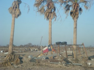
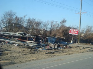
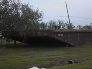
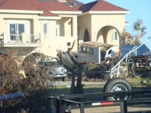
Southeast Texas has had its share of storms of the tropical nature throughout history. Many of our residents have suffered greatly at times, but for the most part, they have soldiered on and rebuilt time and time again. In recent history, we have seen firsthand the suffering of our residents and their enormous losses due to the viciousness of these monsters. Two hurricanes in particular, Rita in 2005 and Ike in 2008, brought devastation to our area in a span of three years. Both were catastrophic for very different reasons. Rita’s fury battered Southeast Texas with winds in excess of 120 mph, while Ike surged the waters of the Gulf of Mexico inland, ravaging many lives and properties from Galveston to Cameron Parish, Louisiana. Through both storms, Sabine Pass became part of the Gulf of Mexico for a short time under surges of ten feet (Rita) and twelve feet of water (Ike). The Bolivar Peninsula, untouched by Rita, was totally destroyed by Ike.
Before Hurricane Rita, there had been a 48-year absence of major storms hitting directly in my part of Southeast Texas (The Golden Triangle), but these years weren’t without incident. Hurricane Alicia battered Galveston with brutal force in 1983, although it did little damage to my area. You can also add both tropical storms named Allison into the mix. In 1989, tropical storm Allison dumped 25 inches of rain over Southeast Texas causing $560 million in damage. Twenty-two years later, tropical storm Allison would make her return to Southeast Texas, this time dumping 40 inches of rain on Houston in just a few days and causing $5.5 billion in damage. The year 2001 would be the last to see the name Allison used by the Hurricane Center.
Hurricane Carla, a major hurricane in 1961, hit Freeport head on, but it also devastated many on the upper Texas and Louisiana coastlines. Parts of the city of Groves were flooded by this malicious and deadly storm. I had always thought it to be from the storm surge, and I guess in a way it was, but I found it odd that Groves was flooded but the city of Port Arthur was not (before the levee was built). I found my answer this week while talking to an early resident of Port Arthur who now lives in Nederland. Like Hurricane Ike, the Gulf waters rose, but as the storm’s eye hit further down the coast, the surge wasn’t as bad here. What was bad was the torrential rain north of the coast. With the high tides and storm surge from the Gulf of Mexico acting as a damn for the run off of Carla’s tropical feeder bands, the water had nowhere to go but into the low-lying parts of the city of Groves, via the Neches River.
Other storms have made their mark as well: Audrey (1957), the storm of 1915, which flooded most of downtown Port Arthur and the surrounding low lying areas, and of course no one could forget the worst natural disaster to hit our shores in the history of the United States—the Galveston Hurricane of 1900. A very good book by Erik Larson called Isaac’s Storm chronicles in detail the events leading up to landfall and the life of the chief meteorologist of Galveston at the time, Isaac Cline.
One year stands out in Texas’s history as well as our own—1886 was a year much like 2008 for Texas. During the season, four of the twelve storms made landfall along the Texas Gulf Coast, two of which affected Southeast Texas. The first made landfall at High Island on June 14. Looking through the records, I have found no accounts of the damage caused by this 100 mph, Category 2 (on the Saffir–Simpson scale) storm caused as it passed through the area.
Mother Nature’s next installment for the Texas coast then turned toward Matagorda Bay and the historic town of Indianola when a mammoth storm approached its shores. Indianola was no stranger to hurricanes; it had already experienced a Category 3 storm in 1875. The town was rebuilt in 1876 and again served as a port where German immigrants entered Texas. But on August 20, 1886, that all ended. The town was totally destroyed by a Category 4 hurricane with winds reaching in excess of 150 mph. The town was never rebuilt.
The third storm to hit Texas that year made landfall in Brownsville on September 23 as a moderate Category 1 hurricane but did not affect Southeast Texas.
Here in Southeast Texas, the trend of minor storms came to an end on October 12,1886, as a Category 3 hurricane ravaged our area. Winds reaching over 120 mph and a storm surge of over ten feet flattened all that stood in its way. The small township of Aurora (the predecessor of Port Arthur) was completely destroyed along with multiple sawmills and homes in the surrounding area.
In Southeast Texas hurricanes have visited us in the past and will surely visit us in the future, but one thing is for certain—the residents of Orange County to Galveston County will meet the challenges head on. Our feisty bunch of land owners are a breed apart, and they cherish their coastal living. Just ask a Bolivar Peninsula or a Sabine Pass resident, and you will hear the same defiance in their voices as those of the early settlers. We will rebuild!
To see more photos please click on the links below.
