Rediscovering Anahuac / Wallisville


DSC03932


If you’re like me, Anahuac is an exit sign off the I-10, which you pass as you go to and from Houston. Yes, you may notice a few old buildings lined up next to the post office, and if you’re really observant, you may see the old church that sits in the background amongst the many old oaks along the streets. A thought might enter your mind to visit this place one day and find out what these old buildings are and why they were built in the first place. But, if you’re like me, your life will get in the way, and you will forget—until your next trip to Houston.

Well, let’s flashback to last year. I acquired a job in Anahuac itself and my travels took me much farther than Exit 813 by the McDonalds. I found out that Anahuac is actually about seven miles south of the Interstate. So every other week, I travelled to this city, oblivious to its rich historic past.

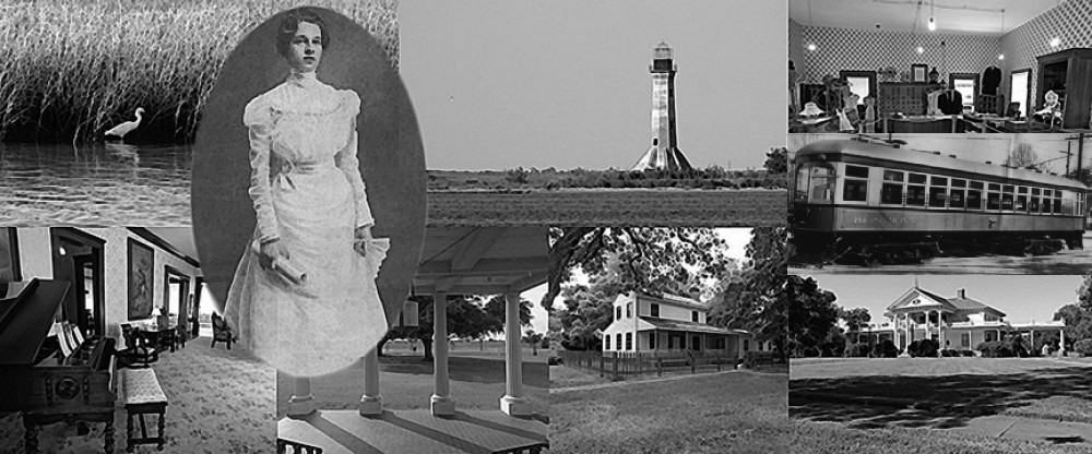
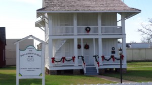
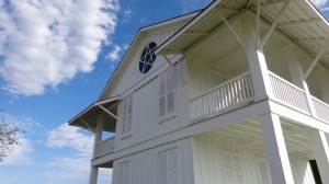
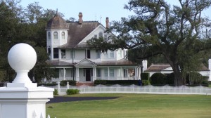
One day, I made a wrong turn and ended up near the Chambers County courthouse. An odd old house caught my eye. It was two-story dwelling with nice porches and a very interesting window. I immediately stopped and felt compelled to investigate.

DSC03926

The house had belonged to a certain Thomas Jefferson Chambers, a lawyer, land speculator, and namesake for Chambers County.

Fast-forward to a few weeks ago when I took a trip to Anahuac to spend the day getting to know its sites and places of interest. And what a day it was. I found out that the Chambers County Historical Commission has a museum located across the street from the Chambers House. It is filled with photos and memorabilia of early families, landowners, and the history-makers of the past few centuries. It’s interesting to note that most of these people’s names are familiar to us from roads, bayous, and such, but most of us are unaware of the historical impact they’ve made. I guess that’s true for wherever you live.

Another plus to visiting this museum was how insightful and knowledgeable the docent was in explaining each photo and artifact. This in itself makes the visit worthwhile.

After spending time at the museum, we were lucky enough to have the Chambers House opened up for us to tour. This house, although small, was intriguing to me. From the large porches and spiral stairwell to the Texas Lone-Star window, I could see myself living there. I also enjoyed the period furnishings in the house, which were all decorated for Christmas to boot. DSC03912

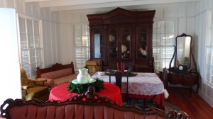
Our next stop was Fort Anahuac. Sadly, nothing is left of the fort, but there are markers explaining the history. (Note: Fort Anahuac was the site of the first armed confrontation between the Anglo-Texan and Mexican troops in June of 1830.) The bluff that the fort sat on was also the site for those immigrating to what was then Mexico. As an aside, the immigrants of the time were required to pay taxes upon arrival!

Before our final stop, I took a back road and discovered an old cemetery, along with a row of oaks, which had been watching over the area for multiple centuries. It was just a beautiful sight to see, particularly since they were decorated with Spanish moss, which was hanging from their branches.

DSC03947

Near the Wallisville Heritage Park (you remember those old buildings and the post office on the highway?), we came across a house that I never knew existed. It is simply a wonderful structure—unfortunately it is private, and we were not able to tour. After doing some research and asking the docent at the Wallisville Heritage Museum, I found out that the house is the Archie and Effie Middleton House circa 1906. Their son, John Middleton, one of the founders of Heritage Park, lives there. DSC03953

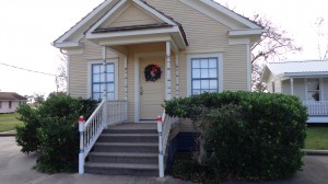
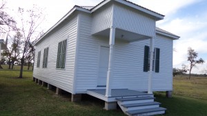
Finally, after having passed it multiple times over the years, we arrived at the Wallisville Heritage Park. This private nonprofit organization was founded in 1979 by John Middleton and some others who were interested in saving the Wallisville town site. A few buildings were saved, moved to their current site (on the Interstate) and restored. One treasure is the old Wallisville schoolhouse circa 1869.

Just like the Chambers County Historical Commission Museum, there are a lot of interesting artifacts and tons of old photos. It is a memorial to a town that was nearly forgotten, as many are in our history. But thanks to John Middleton and those concerned citizens who took it upon themselves to save our history, these artifacts have been preserved.

DSC03956

As our tour of Anahuac/Wallisville’s interesting and historic sites came to a close, I felt certain I would be back again. There is much more to see. I guess I’ll need to call Houston next time and tell them I’ll be a little late.

Sabine Lighthouse


I can point to one site in particular that originally sparked my love for local history over 20 years ago. In fact, when I rediscovered it in 2009, it brought back a lot of memories. It was the reason that I started writing again and began my journey to rediscover our past. What is this place you ask? Well, actually, it’s technically not in SETX.


Just southeast of the Sabine Pass Battleground, stands a weathered and abandoned but still majestic-looking brick lighthouse that has seen and been a part of our history for many years. Even though it resides in Southwest Louisiana, I believe its roots justify honoring this historic site for both states.


I first saw this landmark back in the late 80s while fishing with a couple of friends. I was then—and still am to this day—in awe of this structure. But alas, it’s yet another part of history that’s yelling out to be saved. Unfortunately, the attempts to purchase and restore the site have not panned out, as it all comes down to money. And I’m certain it would take far more than would be available.


So how did this landmark come to be? Well, on March 3, 1849, Congress appropriated $7500 for a lighthouse to be built at Sabine Pass, but naval commander Henry Adams investigated the site and felt there was no need for it. So all of the money, less $116.80, was put back into the surplus fund.

Local citizens strongly disagreed and continued, with the help of politicians, to petition Congress for a lighthouse. Finally, four years later, Congress appropriated $30,000 for a lighthouse to be built after a different surveyor suggested that one be built on the east side of the pass. The land was obtained, and work began in the latter half of 1855.


The 80-foot-tall brick lighthouse went into service in late spring or early summer of 1857 but would cease operations a little over four years later with the start of the civil war.


During the war, the Union army used the lighthouse to spy on the progress of the Confederates, who were constructing Fort Griffin at Sabine. Unfortunately, they lost their prized looking post in April of 1863, five months before the Battle of Sabine Pass, when the lighthouse was seized by a small group of Confederates.


Oh, how different history would have been if the Union soldiers had kept the lighthouse. With their knowledge of the fort, including the fact that it had no protective back wall, one can only imagine that the Battle of Sabine Pass would have been nothing more than a skirmish after 6000 Union soldiers flanked the 50 Davis guards and Lt. Richard Dowling. Sure, they still would have to have dealt with Kate Dorman (see Kate Dorman post), but even Kate probably couldn’t have handled all those Federals by herself.

The lighthouse returned to service on December 23, 1865, after the end of the war, and its beacon would continue to shine for more than 87 years. There would be many trials and tribulations within this time, especially of the tropical kind.


In October 1886, a strong tropical cyclone ravaged Southeast Texas and Southwest Louisiana (see The Destructive Side of History post), destroying the keeper’s house adjacent to the lighthouse. Some have said that the surge was 10 feet high while others say 20. But whatever the actual height, it left total devastation in its wake and 150 dead in Sabine Pass—except for the lighthouse across the Pass.


There would be other storms that raged upon this land, but the structure has stood sound throughout. It took  the winds of progress to seal its fate. On the morning of May 21, 1952, the light dimmed for the last time, ending a part of our history forever.


Today it sits in hazardous decay. Unsafe to enter, but from afar, it still holds the majestic glow that I have come to love. I hope that one day she will be saved, but it will be a long and hard journey before her light shines again.


Elisha O. Brewer Cemetery


Not many people know about the grave off Amoco Road just south of Beaumont. I never knew of it until it was pointed out to me while I was working at Oiltanking Beaumont (formerly Amoco). After looking over the cracked stone, I knew there was a story there, but what story, I did not know.

That night I did an internet search for Elisha Brewer, the name on the headstone, and found an article written by W. T. Block, which was first published in the Beaumont Enterprise on November 13, 1999. It told the story of Elisha O. Brewer, who, after visiting the deathly ill mayor of Beaumont, Columbus Caswell, had been un-harnessing his wagon when his horse had kicked him in the groin. Elisha died a short time later. He was 31.

Elisha Brewer was the grandson of Christian Hillebrandt, a cattle baron, who was the namesake of Hillebrandt Bayou. His wife Mary was the granddaughter of John Sparks, the first settler and founder of the Sparks settlement (Aurora), which was the precursor to the city of Port Arthur.

It is unclear why Elisha O. Brewer had been buried in what would have been his backyard 129 years ago. Possibly it was out of haste or necessity, but whatever the reason, we can assume from the words on his gravestone that he was deeply missed.

“Since thou canst no longer stay

To cheer me thy love

I hope to meet with thee again

In yon bright world above.”

Elisha O. Brewer

February 2, 1852 – August 5, 1883

The grave is located less than a hundred yards from Amoco Road, and the small fence surrounding the hallowed site can be seen from Highway 347. Although it is technically on Oiltanking Beaumont’s property, it is not located in a fenced or restricted area. With that said, I do make a point of driving past the grave and up to the guard shack and explaining to security why I’m there and what I am doing.